Snow, ice to impact Historic Triangle during long-duration weekend storm
WILLIAMSBURG – A winter storm is set to bear down on all of Virginia this weekend, but wild shifts in the forecast over the past few days have made it difficult for many local residents to know what to expect here in the Historic Triangle.
Earlier this week, some models showed that a foot or more of snow could fall across Hampton Roads. Meteorologists say the track of the storm shifted northward over the past 72 hours, leading to a change from all snow to mixed precipitation across Southeast and Central Virginia.
While that may be disappointing news for snow lovers, the change does not mean that the impacts will necessarily be reduced. The most recent forecasts are calling for some combination of snow, sleet and freezing rain to sweep across our region over a long-duration storm.
An extended period of freezing rain would be the worst-case scenario.
The National Weather Service (NWS) in Wakefield has issued a winter storm warning for the entire state. The warning is in effect from Saturday at 1 p.m. all the way through Monday at 7 p.m. A State of Emergency has also been issued for Virginia.
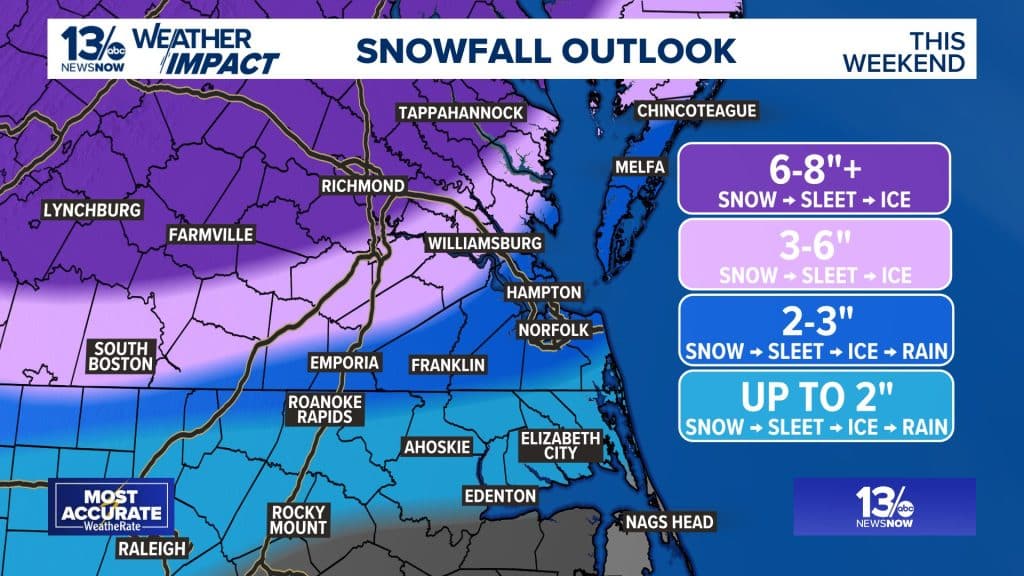
The most recently updated warning is calling for heavy mixed precipitation throughout the region. Local meteorologists are calling for anywhere between 2″ to 6″ of snow for the Williamsburg area.
The storm is part of a massive system impacting more than 200 million Americans across a 2,000-mile stretch of the country. It is expected to be slow-moving, leading to a long-duration event.
The weather in our part of the world is notoriously difficult to predict, but this storm has been especially challenging, forecasters say. That’s because slight shifts in the temperature or atmospheric conditions could mean the difference between snow, sleet, freezing rain or just a cold rain.
A transition to sleet and freezing rain is expected after midnight. This will be a critical point in the storm as extremely slick conditions are likely, and trees and power lines could be impacted.
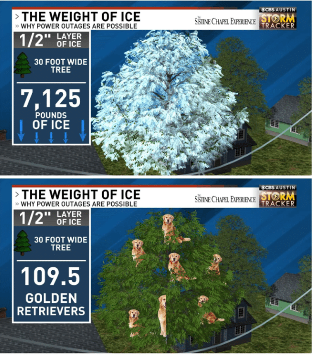
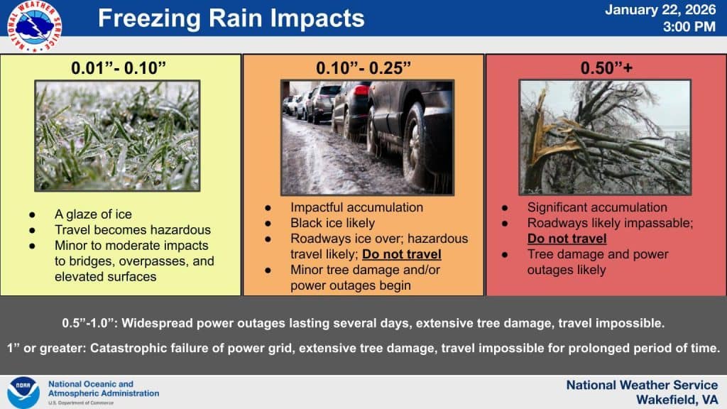
While explaining the impacts of the cross-country system, Meteorologist Avery Tomasco of CBS Austin offered an interesting example of the woes that come with freezing rain. A .50″ layer of ice on a 30-foot tree equals 7,125 pounds of ice, which is equivalent to 109.5 golden retrievers, he said.
According to the latest NWS update, up to .50″ of freezing rain could fall in the Historic Triangle. That would make travel nearly impossible, and widespread tree damage and power outages would become likely.
Even if freezing rain totals are lower, between .10″ and .25″, black ice would become likely as roadways ice over, making travel treacherous. Power outages would be possible.
There are still unknowns surrounding the rest of the forecast during the second half of the storm.
Sunday “is shaping up as the most complicated and potentially dangerous day of this storm,” according to 13News Now meteorologist Craig Moeller.
Surface temperatures during the day are expected to climb, and highs will reach the mid-30s. That could lead to periods of cold rain or sleet and freezing rain, which will continue for hours. Precipitation is expected to continue into early Monday before tapering off.
Roads could remain icy well after the storm moves out, and power lines are also at risk of failure after the precipitation ends.
“Forecast ice totals are unfortunately starting to rival what was received during the 1998 ice storm, as well as 2021 storm in south-central VA,” the National Weather Service in Wakefield shared in a Jan. 24 Facebook update. “Both resulted in devastating power infrastructure interruptions. Also of note with this one is some wet snow will fall before the ice, meaning extra weight on tree branches and lines.”
Ultimately, this is a case of preparing for the worst and hoping for the best.
Arctic air to linger for days
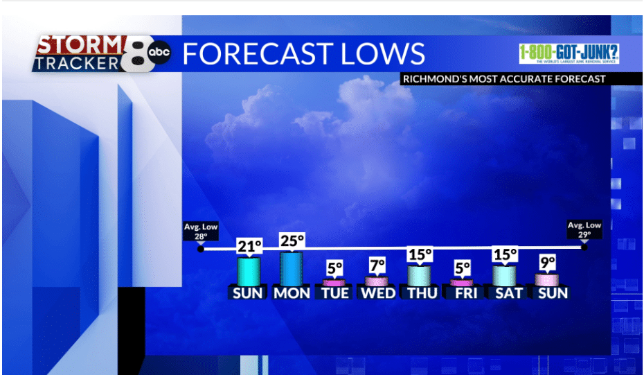
What we do know for certain is that the next several days are going to be very cold. The frigid temperatures are a major concern, particularly because of the risk of widespread power outages.
Highs will not surpass the mid-30s for the entire week. Low temperatures will fall between the teens and single digits, while windchills will make the temperatures feel more like zero or below zero degrees.
VDOT, Dominion continue preparations
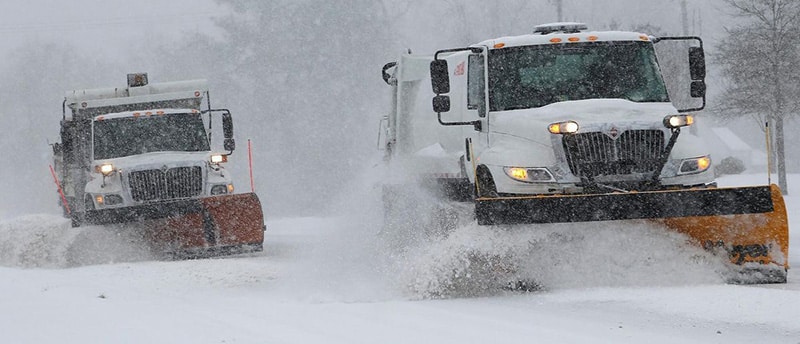
The Virginia Department of Transportation (VDOT) has begun preparations for the winter storm throughout Hampton Roads. Crews were first mobilized on Thursday.
Pre-treatment operations are underway on state-maintained roadways as well as county primary roads and some major secondary roads in the Historic Triangle and the Eastern Shore.
Drivers are asked to remain on the lookout for slow-moving operations and give extra space around trucks and equipment encountered on the roads.
“Based on the latest forecasts indicating potential for a significant icing event with a mix of winter precipitation, from snow to sleet and freezing rain, the public should complete preparations ahead of the storm to avoid all non-essential travel during and for a period following the storm, until conditions improve,” a VDOT-issued statement said.
VDOT operates a free 511 mobile app, which offers information about road conditions, traffic incidents, weather and more. Details are also available by calling 511 while in Virginia.
To report hazardous road conditions on state-maintained roadways, motorists can contact VDOT’s 24-hour customer service line by visiting my.vdot.virginia.gov or calling 800-FOR-ROAD (800-367-7623).
Dominion Energy has also mobilized hundreds of crews and thousands of lineworkers, patrollers, foresters and other personnel to support power restoration efforts. Contractors and utility workers from other states are also ready to assist with the effort.
“Our crews are preparing for widespread power outages from heavy ice and snow accumulation across our service territory beginning Sunday and into early Monday morning,” Dominion said in a statement.
Officials share safety tips
State Health Commissioner Dr. Cameron Webb warned that in addition to road hazards, ice is a common cause of emergency room visits.
“A lot of times we’re seeing folks who suffer fractures because they weren’t expecting to step out on some ice,” Webb said. “So we want people to be really careful. That’s why we’re saying stay indoors if you can. If you must go outdoors, make sure your footwear has really good traction.”
Officials are offering the following tips for preparing for the upcoming storm:
- Ensure all electronic devices and rechargeable batteries are fully charged.
- Winterize your car by filling your gas tank and checking the oil level. Keep an emergency kit in your vehicle with a flashlight, jumper cables, a blanket, an ice scraper and first aid supplies.
- If you have a generator, make sure you fuel it and know how to use it.
- Keep non-perishable food, water and medical supplies on hand at home.
- Insulate your home as much as possible.
- If the power goes out, use weather stripping or towels to block cold air from coming into windows and doors. Layer up with a sweater, jacket, hat and gloves.
- If you lose access to heat, keep windows and doors covered and closed. Allow the sun to bring heat into your home during the day, but close blinds or curtains at night to provide a buffer against the cold air. Rolled up towels or rags can help prevent cold air from entering through seams around doors or windows.
- Do not use a generator, grill, camp stove or gasoline, propane, natural gas or charcoal-burning device inside your home or any other partially enclosed area.
- Check on elderly, vulnerable or disabled neighbors, relatives and friends.
For additional recommendations, visit the Virginia Department of Emergency Management website.
Thanks for reading! Will you help make our journalism possible?
The Triangle is a uniquely independent news source for Virginia's Historic Triangle and the surrounding region. We need our community's support to keep producing quality local journalism.
Author